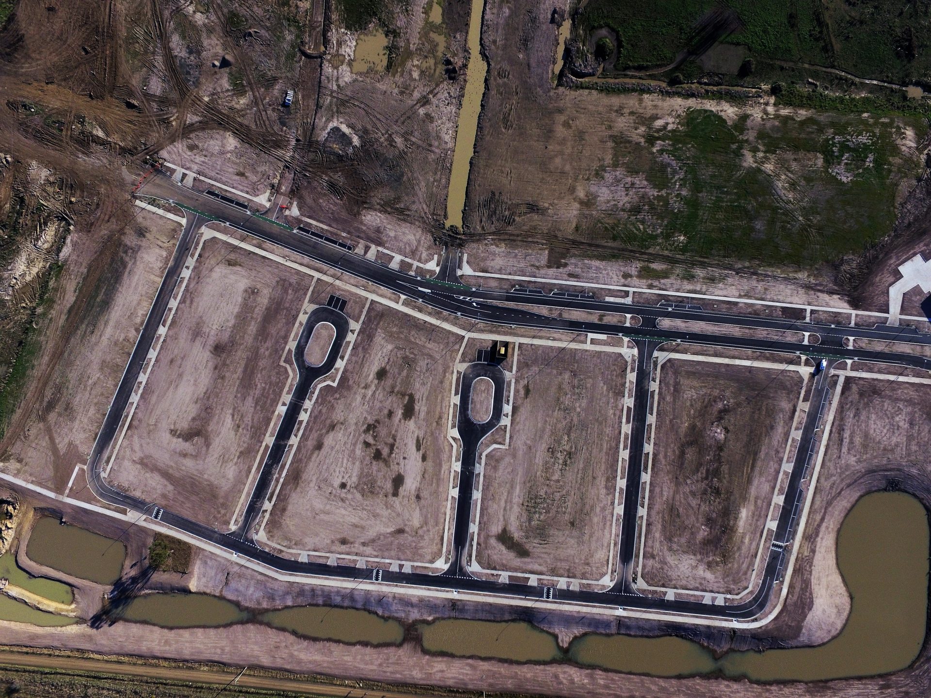
Land surveying is one of the oldest disciplines of civil engineering, dating back hundreds of years to Medieval days when the lords and ladies needed to establish the limits of their feudal empires. If the French had sent out a few surveyors ahead of time they might never have sold the Louisiana Territory to the United States for $18 per square mile – quite possibly the worst real estate deal in history! Surveying is still very important in modern engineering, aiding in design and construction and helping keep legal property lines and boundaries.
Homeowners need to know the basics of land surveying because there is a good chance they’ll need to work with a land surveyor on their property. A good survey can help settle a legal dispute over property lines or help establish a site plan for a new home. Surveying technology has improved dramatically over the last few decades thanks to GPS, drones and LIDAR, resulting in more accurate surveys and less hassle for homeowners.
Intrax Consulting Engineers offers leading surveying services to complement PredictSite's site classification for the full end-to-end offering, to assist all your home building needs. Check out Intrax's scope of surveying services and get your survey report here.
What is a Survey Report?
A survey report is the final record of all the data points collected by the survey team in the field. A survey report’s primary aim is to clearly and cleanly map out site conditions, whether it be detailing levels, buildings, title dimensions or drainage pits. The surveyor will ultimately produce a 2D or 3D plan that can being either viewed in 2D when printed out or 3D in CAD. The 3D CAD file will then be used as the foundation of all civil engineering and construction plans.

What are the different types of survey reports in Australia?
In Australia there are many different types of survey reports and plans within the residential, infrastructure and construction markets. These reports are provided for various reasons including assisting designers, estimators and builders in the construction process. Each survey type and report serves a different purpose, so be sure you are selecting the right kind of survey for your project. In this section we’ll discuss the different kinds of surveys, when each is required, and why they are important.
What is a feature survey / detail contour survey?
A feature survey or detail survey is the first step in the land development process. The plan shows the levels, features, boundaries and contours of the land so designers can complete house and unit designs prior to the construction phase. A feature survey will also capture details on adjacent properties. A feature survey is a must when starting a new project because it gives a complete picture of every existing feature on the site that must be considered in design.
What is a title re-establishment survey / Boundary Survey?
A title re-establishment survey includes physically marking the boundary corners and supplying a supporting survey report. Title re-establishment surveys are important in setting clear property boundaries when records have been lost over time or neighbours cannot agree on where the lines fall. Surveyors will consult historical records as well as perform measurements in the field to legally re-establish property lines.

What is a identification / neighbourhood survey?
An identification survey, aka neighbourhood survey, is essentially a feature survey that encompasses a much wider area of land. Identification surveys can capture topographic and land features from as many as 50 adjoining parcels. An identification survey may be requested by a town council to ensure that all properties and homes are being developed to their own strict standards. An identification survey is unlikely to have much impact for a single homeowner.
What is a survey to AHD?
A survey to AHD is a height survey to the Australian Height Datum. It is required by engineers, architects and authorities to determine design levels to ensure there aren’t issues such as flooding on a property. If you live in a flood plain, a survey to AHD will help you determine where you can set your first floor. The AHD has only been established since the 1970s, so properties that have not been surveyed recently may work on a different system.
What is a survey to original datum?

A survey to original datum is similar to a survey to Australian Height Datum. Not every property has been surveyed using the AHD as its datum. If the property has not been surveyed as such, research will have to be done to determine the original datum so that it is possible to have an accurate elevation.
What is a cadastral survey?
A cadastral survey maps out the legal boundaries of your property in accordance with your deed and title. The cadastral survey serves as a legal record of your property and is required when making a land purchase. It is important to know exactly where your property ends and your neighbor’s ends to avoid future conflict over construction or responsibility. There are various Cadastral and Land Surveying reports in the residential market including detailed surveys, reestablishment surveys, boundary marking, Identification surveys, Strata and Subdivision plans
What is a construction survey?
Surveys and reporting for major construction and infrastructure projects are used to assist in the design and construction phases. Construction surveys include detail surveys, volumetric surveys, set-out surveys, conformance reports, Quality assurance, monitoring and as-built survey reports. Contractors on large projects utilise surveyors to keep their projects on track and make sure they are working according to plan. If you’re building a new home from scratch, it may be a good idea to reach out to a surveyor to perform a final as-built survey after construction is complete to ensure you got exactly what you paid for.
What is a set-out survey?
A set-out survey is a critical step in transferring a building, bridge or road from the engineer’s plan to the real world. The surveyors will head out to the site with plans in hand and stake out the project’s footprint for construction workers. For example, a set-out survey may stake where to excavate for a basement or bridge abutment or locate edges or paving. The work by the surveyors make it possible for construction work to be performed precisely.

What is a contour or topographic survey?
A contour or topographic survey captures the slopes and grading of the land. This surveying work may be included with a full feature survey. It is important for homeowners and builders to have a record of their site’s contours and topography. The contour survey will help identify where stormwater runoff may concentrate or how to excavate for foundations or slope a driveway. Engineers will work with you to interpret the contours on your site.

Surveying FAQs
What is the purpose of cadastral surveying?
The purpose of cadastral surveying is to define or redefine the legal boundaries of a block or property. A cadastral survey is needed if you are purchasing a property and need to ensure you are purchasing the correct block of land. Furthermore, if you are building on titles, a survey is needed to ensure all works are built within your title block. A cadastral survey will also determine existing boundaries if they have not been previously surveyed. This process of surveying dates back to 17th Century England.
What is a property or land survey?
A land survey is a feature survey of existing conditions on a property. It is essentially a map of all the topographic features on a property. These surveys are a basic prerequisite for building a home or developing an empty parcel of land. The survey will establish exact locations of features on your property like vegetation, contour lines and grading, drainage features, utilities and buildings. The land survey will serve as one of the key building blocks to moving forward with your project.
What is included in a surveyor’s report?
The surveyor’s report will include a full description of all existing site conditions relevant to the project. What is included in the surveyor’s report varies depending on whether you are conducting a feature survey or title re-establishment. If you are doing a feature survey, the report should include site conditions as of date of survey and will serve as a detailed plan view of the site. If you are looking at a re-establishment survey, it will include title information and existing boundary locations.
Is it worth getting a survey of a house?
Yes. As a land purchaser, it’s important from a legal point of view to have a re-establishment survey done to avoid the risk of buying an inaccurately drawn up block of land. In the past, real estate agents in regional or rural areas have thought they are selling one lot, but actually took their client to the wrong lot.

If you are planning on building or developing a site, performing a feature survey or re-establishment survey is definitely worthwhile. A feature survey will give you a better idea of what you will need to work around when clearing or developing your site. Intrax can offer a package that you can take to any builder or architect and come up with a surveying plan that can meet your project-specific needs.
What is the purpose of having a survey done on a property?
The purpose of a re-establishment survey is to define property boundaries. The purpose of a feature survey is to map existing site conditions and put it on a 2D or 3D plan. For the housing market, Intrax primarily provides either feature surveys for new estates, houses or blocks that are vacant or re-establishment surveys for real estate transactions. A feature survey helps engineers and builders set up their site plan and understand where they can build, while a re-establishment survey serves as a legally binding record of property boundaries.
How much does a survey cost?
There are a lot of up-front costs when purchasing a home or block of land for development, so it’s understandable that homebuyers might be looking to save a little cash by skipping a survey. A quality survey in Australia should cost between $1000-$2,500. That’s a drop in the bucket compared to all of the legal headaches that could come down the road if you get into a dispute over property lines with a neighbor or fail to locate utilities and accidentally strike a water or gas line while excavating for your basement.

What house survey should I get?
If you are purchasing a new home, a re-establishment survey is required. The re-establishment survey is the bare minimum level of survey detail that can help the homeowner. If you are developing an existing block of land or renovating a building, you would require at least a feature survey, and potentially a re-establishment survey depending on how recently one was performed. Any development requires a feature survey, which is key to getting council approval or planning permits.
What does a boundary survey include?
When a boundary survey is requested, the surveyor’s task is to give you a formal record of your property lines. A boundary survey includes a measurement of the property and where the existing fence lies in relation to the current title. The surveyor will mark the boundaries and produce a plan of re-establishment. Included in the boundary survey is a review of existing property records and deeds. Combined, all of this leads to the definition of a legal boundary that stands up in court.
What do property stakes look like?
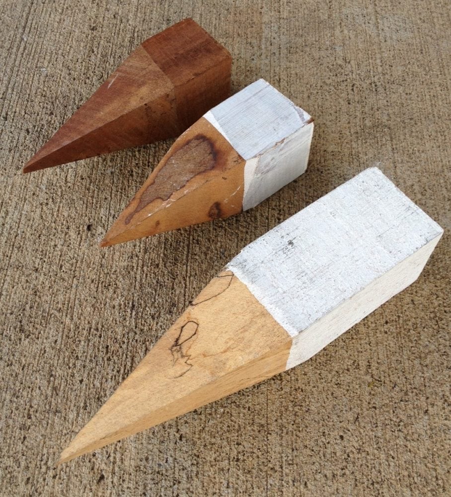
A title peg or property stake is traditionally a 30x30mm red gum (or sometimes plastic) square block that is painted white. It can also have a lot number stamped onto it as well. The stake is pegged into the ground, where it defines the physical location/corner of the boundary. It can also be accompanied by a stake or flag to be easily spotted.

When a lot is developed for the first time, the builder or developer will typically leave at least one permanent marker to help establish boundaries in the future. This could be something like a small piece of steel rebar or rod sunk into concrete at each corner of the property.

Join the dozens of home builders and developers who have turned to PredictSite and Intrax to cut down on their geotechnical costs, provide faster, more accurate estimates, refine their slab designs and determine how best to address problematic soils.

